Downloading Data from USGS and EE
Article By Kelly Sharpe
Time for a little data update and primary reason for this article. For those who have been downloading data from the USGS (United States Geological Survey) EE (Earth Explorer) website, you have noticed in the past couple years that things have changed very dramatically. This article will give you some good info and food for thought.
HISTORY: Dec of 2020 ago, we were downloading Landsat & Sentinel satellite imagery and Lidar from this site and all of the data could be converted to be used in GK Technology’s ADMS (Ag Data Mapping Solution) Software. Over the past 2 ½ years, the USGS – EE website has changed it’s data dramatically. In 2021, all Landsat Collection 1 – Level 1 data became un-available. This was the data that we developed ADMS to convert and process. Also in 2021, USGS quit hosting Lidar data from the EE website. In 2022, the USGS quit hosting the ESA (European Space Agency) Sentinel satellite imagery data. End result, the place where we were getting the majority of all of our data was now supplying us with NO DATA.
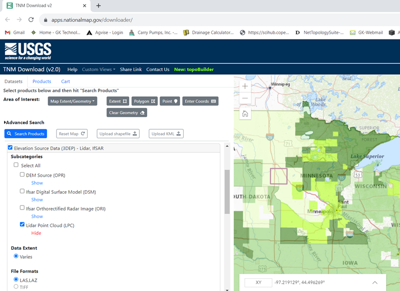
LIDAR: The USGS is still hosting up the data it had and is actively getting new data. None of it is available via the EE site. The new site is the USGS – National Map site – https://apps.nationalmap.gov/downloader/ . NOTE, currently, we do NOT have instructions for using this site. Also, be aware that Lidar Data gets distributed in many different ways, from many different locations. This site may not have the data you are looking for!

SENTINEL: Imagery here is flown and supplied by the ESA giving us 10-meter imagery roughly every five days. We are now getting data from Scihub Copernicus Open Access Hub; this is an extension of the ESA. See the GK Website – Data Links https://gktechinc.com/data-links/ . We have instructions on downloading and processing data here. Please note that getting new data works well, getting previous years can be a little slow, as you must put in requests. Final item of note, in the next month or two, the Copernicus site is getting revamped with a new layout and functionality. So, there will be new instructions coming here soon!
LANDSAT: USGS has been hosting data here for many years. The Landsat 30-meter imagery with LS8 & LS9 gives us imagery every eight days. The new instruction for downloading and processing data are on the GK Website – Data Links https://gktechinc.com/data-links/ under the USGS links. Some items of note, all of the data downloaded is now Collection 2 – Level 2 and all imagery is now 16-bit, vs in the past some was 8-bit, some was 12-bit. Darin had to re-write all the import tools. Landsat tools are much easier and faster to use.
NAIP: USDA GeoSpatial site has been hosting data for the FSA NAIP (National Ag Imagery Program) in the USA. GK Website – Data Links https://gktechinc.com/data-links/ to see the USDA GeoSaptial links. Data gets flown by airplane during the summer and fall at least one time every three years for all agricultural areas. Original data was flown in 2002 & 2003 at 2-meter resolution, around 2005 most went to 1-meter, around 2017 most went to 0.6-meter and in 2023 many will be going to 0.3-meter or roughly 1-foot resolution. NOTE, there is a lot more data here than the NAIPs. It also has Township, Sections, Roads, Waterways, and other useful data.
ADMS CONSULTANTS PACKAGE: All the items here are not just impacting ADMS users who are looking for data to download and process. It is hitting us also, trying to have the image libraries that GK Staff and Consultants Package users use has turned into a full-time job. All these web changes are hard to keep up with when you are downloading 100’s of images a day for roughly 25 States and 5 Provinces. Not to mention maintaining servers and data once processed. We do our best to have imagery within seven days of the flights. End result, ADMS users simply need to have Field boundaries and internet access to get imagery and topo for their fields.
KELLY’S SUMMARY: GK Technology, Inc. was formed in 2006. We were downloading Landsat data from UMAC (Upper Midwest Aerospace Consortium) where they did all the band processing and Darin programmed ADMS to use the data. UMAC data was free and worked with no extra work, and USGS data cost $$ (think it was $150 a Landsat Scene) and required us to process the data in another GIS software, took about 1 to 1.5 hours per image. UMAC was running on grant money, and the well went dry. Website disappeared; data disappeared. I remind everyone who is using web base data or web data hubs, it is there today, may be gone tomorrow. In our 17+ years as GK, we have watched sites and data hubs appear and disappear. Don’t be complacent, get data on local drives in useable formats. There is nothing that says these sites will not go to charging $ for data or that they will quit hosting data to the public. If you want data, go get it, don’t wait 😊
Please reach out with any questions or comments.
